
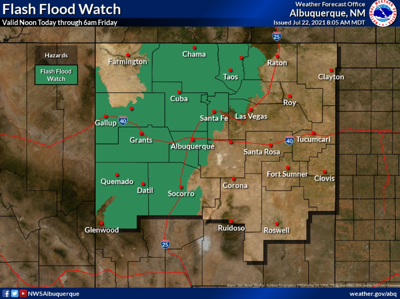

The National Weather Service and Albuquerque issued a warning of potential flash flooding across central and western New Mexico for Thursday and Friday (July 22-23), with Taos County in the predicted impact zone. The warning remains in effect from 12 p.m. today (Thursday) throughout the night.
The National Weather Service warns an estimated 2 inches of rainfall per hour is possible. The heavy rainfall, along with the combination of slower storm motions may lead to flash flooding, according to the National Weather Service.
“An approaching low pressure system combined with continued above normal moisture will yield numerous showers and thunderstorms across much of central and western New Mexico Thursday afternoon through Thursday night,” read the advisory.
Storms are expected to move toward the southwest area of the state at approximately 5 to 10 miles per hour.
The advisory warns that residents in affected areas should monitor forecasts and be prepared to take possible action to avoid flooding if necessary, particularly those located downstream of wildlife burn scars, or in areas that have recently received heavy rainfall.


(0) comments
Welcome to the discussion.
Log In
All comment authors MUST use their real names. Posts that cannot be ascribed to a real person
will not be moderated.
Keep it Clean. Please avoid obscene, vulgar, lewd, racist or sexually-oriented language.
PLEASE TURN OFF YOUR CAPS LOCK.
Don't Threaten. Threats of harming another person will not be tolerated.
Be Truthful. Don't knowingly lie about anyone or anything.
Be Nice. No racism, sexism or any sort of -ism that is degrading to another person.
Be Proactive. Use the 'Report' link on each comment to let us know of abusive posts.
Share with Us. We'd love to hear eyewitness accounts, the history behind an article.